The consultant team and advisory committee used the Technical and Regulatory Considerations listed below and the Objectives (Objectives tab) as a framework for determining the feasibility of the various alignment and landing options.
 |
| Mayor's Advisory Committee discussing options. |
Technical and Regulatory Considerations
- Minimum bridge/trail widths
- Horizontal geometry constraints (including minimum radii for curves) and allowable design speeds for bicycles
- Maximum allowable vertical grades and rates of curvature for both bridge structures and for access
- Railroad clearance parameters
- Roadway clearance parameters
- Emergency access requirements
- Maintenance access requirements
- Minimum lighting requirements
- Requirements for storm water detention and water quality
- BNSF permit support requirements and timeline
- Identify constructability issues and parameters associated with railway
- Utility clearance requirements
- Structural loading conditions
- Allowable structural deflections and vibrations
 |
| Option A, eliminated |
This alignment launched from Grant Street and crossed directly to the campus node defined by the intersection of pathways from the campus central spine or mall and Main Street. The objective of this alternative was to minimize the structure length and property acquisition requirements.
The main reason this alternative was eliminated was the fact that it draws pedestrians through Grant Street which dead ends on the south side of Sprague. In addition, this pathway does not provide a safe access for pedestrians to cross Sprague.
The bridge would be at a height of 26 feet above the ground on the Riverpoint Campus side. This would require a ramp for ADA access that is approximately 370 feet in length. The disadvantage of this is the lack of space for the large area needed for the ramp and the long distance needed to be traveled for those that could not use a more direct stairway system. An elevator would be another alternative to bring pedestrians down the 26-foot height. The disadvantages to an elevator are the ongoing maintenance costs related to operations of an elevator.
Option B- eliminated
 |
| Option B, eliminated |
This alignment connected to Sherman on the south side, then continued towards Grant along the sloped area between the railroad tracks and the private property boundary and crossed over to campus node similar to Option A. This alignment was eliminated when it was found that the area of land designated for the pathway was owned by BNSF, who has plans for future track expansion within this area.
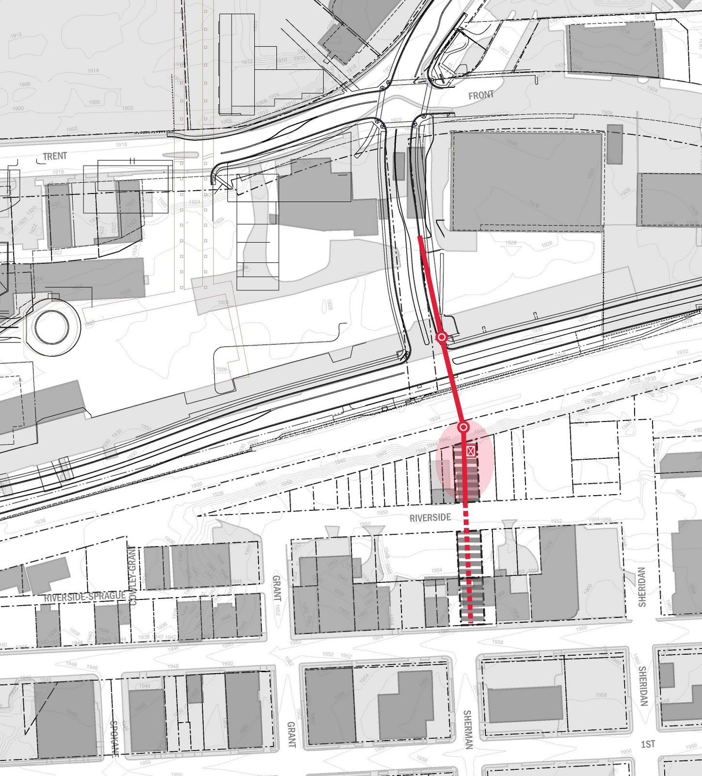
Option C- moved forward as Option 1
 |
| Option C, moved forward as Option 1 |
This alignment is moving forward as Option 1. This alignment is similar to Option A, but it connects to Sherman rather than Grant. The intersection of Sherman and Sprague is signalized thus provides a safe crossing for pedestrians. In addition, Sprague is also a through street traveling south to the medical district and connecting with the overall non-motorized plan of the City. There is also the opportunity to provide stairs that can connect with Grant. This alignment also provides an opportunity to create a green space such as a park or plaza on the south side. Like Option A above, the bridge will be 26 feet above the ground surface when it crosses to the Riverpoint campus. This again would require either a 370-foot ramp or an elevator for ADA access. Again, the disadvantage of this is the large area needed for the ramp is not within the master plan of the campus and the long distance needed to be travel for those that could not use a more direct stairway system. Given the benefits of the connection to Sprague, the opportunity for a green space and the ability to utilize a shorter bridge, this alternative was chosen to move forward with an elevator on the north side (Riverpoint Campus).
Option D- eliminated
This alignment connected to Sherman on the south side and immediately crossed BNSF and landed at the intersection of Martin Luther King Jr Way (MLK) and the future north Sherman.
Like Option A, the bridge for Option D would be at a height of 26 feet above the ground once it crossed MLK. This would require a ramp for ADA access that is approximately 370 feet in length. The disadvantage of this length of ramp is the lack of space for the large area needed for the ramp and the long distance needed to be traveled for those that could not use a more direct stairway system.
 |
| Option D, eliminated |
Two sub concepts were researched related to this options: D2 considered a ramp traveling north along the future Sherman
 |
| D2 eliminated |
 |
| D3 eliminated |
Option E, moved forward as Option 2
This alignment connects with Sherman and then travels at an angle directly to the campus node defined by the intersection of pathways from the campus central spine or mall and Main Street. This is moving forward as Option 2.
The advantage of this alignment is the intersection of Sherman and Sprague is signalized thus providing a safe crossing for pedestrians. In addition, Sprague is also a through street traveling south to the medical district and connecting with the overall non-motorized plan of the City.
 |
| Option E moved forward as Option 2 |
Vertical clearances requirements above the City roadways and transit corridors are less than those required for BNSF; consequently, once the bridge crosses the BNSF right-of-way, the bridge height can begin to come down. Once the bridge reaches the Riverpoint campus, the bridge height is approximately 16 feet rather than the 26 feet in other options. In turn, this reduces the ADA ramp length by approximately 140 feet for a total length of approximately 230 feet. The shorter ramp requires less land area to construct and can fit within the parameters of the campus master plan.